PEARL, Miss. – The Mississippi Emergency Management Agency continues to respond to the severe weather events that impacted the state on May 2, 2021 and May 4, 2021. At this time, no fatalities have been reported to MEMA from either weather event. MEMA understands that there is significant damage to portions of the state due to weather. Our staff is working with county EMA directors to complete damage assessments. Every disaster starts local and ends local. State resources have been provided to the counties that have requested assistance.
The following counties have submitted official preliminary damage reports from the severe weather on May 4, 2021 to the Mississippi Emergency Management Agency:
- Hinds – 113 homes affected; 6 businesses affected
- Leake – 21 homes affected; 9 businesses affected
- Rankin – 7 homes affected
- Newton – 5 homes affected; 3businesses affected
- Warren – 6 homes affected
- Yazoo – 10 homes affected; 1 business affected
As of this morning, the NWS Jackson has confirmed 3 tornadoes in Mississippi from the May 4, 2021 severe weather event.
- Rankin County: EF-1 (90 mph)
- Hinds/Rankin County: EF-1 (110 mph)
- Warren County: EF-1 (105 mph) *This tornado formed in Lousiana and crossed the state line into Mississippi*
As of this morning, a total of 15 tornadoes have been confirmed across the state during the May 2, 2021, severe weather event.
NWS Jackson confirmed 11 tornadoes:
- Hinds County (Terry/Byram): EF-1 (105 mph)
- Yazoo County (Yazoo City) EF-1 (110 mph)
- Madison County: EF-1 (95 mph)
- Holmes County (Durant): EF-1 (100 mph)
- Yazoo/Holmes County: EF-0 (85 mph)
- Holmes County (Eden/Tchula): EF-1 (110 mph)
- Holmes/Carroll County: EF-2 (115 mph)
- Jefferson/Claiborne County: EF-1 (105 mph)
- Attala County: EF-1 (90 mph)
- Leake County: EF-0 (80 mph)
- Choctaw County: EF-0 (80 mph)
NWS Memphis confirmed 4 tornadoes:
- Calhoun County: EF-1 (90 mph)
- Pontotoc/Lee County: EF-1 (90 mph)
- Lee County (Tupelo): EF-1 (100 mph)
- Lee/Itawamba County: EF-0 (75 mph)
The following counties have submitted official preliminary damage reports from the severe weather on May 2, 2021, to the Mississippi Emergency Management Agency:
- Calhoun – 43 homes affected; 6 businesses affected; 2 public bridges affected
- Hinds – 24 homes affected
- Lee – 76 homes affected; 6 businesses affected; 1 public building affected
- Pontotoc – 10 homes affected; 1 business affected
- Yazoo – 76 homes affected; 4 businesses affected; 1 public road affected
*These are preliminary numbers and could change throughout the assessment process.
Residents and business owners can self-report damage from the severe storms on May 2, 2021 and/or May 4, 2021 through MEMA’s Crisis Track Self-Reporting tool.
If citizens have immediate unmet needs, they are encouraged to contact their county emergency management agency. A list of those county contacts can be found here.
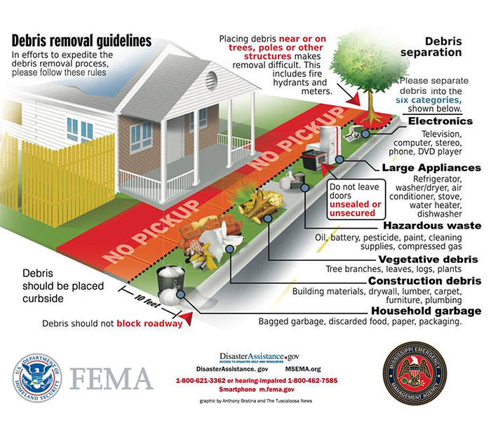
MEMA is encouraging residents to NOT burn debris. Instead, sort debris according to the picture above. Debris is measured and weighed and is a factor when applying for federal assistance.